Wenceslaus Hollar
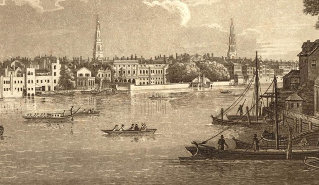
A section of Hollar’s famous Long View of London, originally produced as a five-metre long panorama of the city, it is a bird’s-eye view from above the church of St.Mary Overie in Southwark. He etched it while in exile in Antwerp, probably based on earlier sketches made in London, leading to several small inaccuracies. It was published in 1647 and dedicated to Princess Mary, niece of Charles II and the future Queen Mary II.
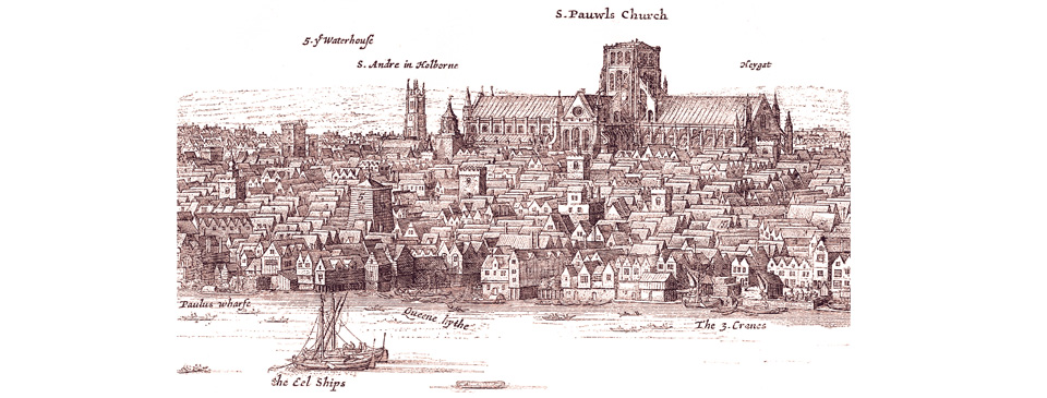
The Great Fire on the other hand was the event that galvanised him into creating some of his best-known and often reprinted works. A week after the flames had subsided he wrote to the King to point out that so many legal documents had been destroyed that a reliable map of London was required. At that very moment Charles and the Privy Council issued instructions for an assessment of the damage to be undertaken and wrote to the Lord Mayor asking him to assist Hollar and to provide the services of Francis Stafford of the College of Heralds in producing “an exact plan” of the post-Fire city. A copy of it was shown to Samuel Pepys in November 1666 who wrote: “And my Lord Brouncker did show me Hollar’s new print of the City, with a pretty representation of that part which is burnt, very fine indeed.” While it is generally acknowledged that the map was engraved by Hollar it seems that the survey for it was carried out by John Leake. In this post-Fire map the ruined areas of the City are in white, indicating the lost streets and sites of major former buildings, which are each numbered and listed. Within the white area streets are shown in the simple plan form that would become the norm thereafter. Around the outside there is a beautifully detailed aerial view of the surviving parts of the City, suburbs and Tower of London in the older pictorial style. Prints of the map were sold by John Overton at Little Britain next to St. Batholomew’s, just outside of the devastated area, and it served as the basis for a large number of maps in broadsheets that were published around Europe giving news of the Fire.
In addition to the post-Fire map Hollar produced an often-reproduced double long-view of London from his usual view-point of Southwark, with an upper panorama showing the City before and the lower one after the catastrophe. Another panorama showed the City in flames.
In 1669 the 62-year old Hollar joined an expedition to Tangier. After their return in 1670 John Overton published the fruits of Hollar’s labours on his travels as Prospects in and about Tangier. Exactly delineated by W:Hollar, his Majesty’s designer. (In later years Hollar’s wife Honora was to sell the original watercolours of her late husband’s trip to the physician Hans Sloane, the man remembered today in the name Sloane Square. Sloane’s collection eventually formed the basis of the British Museum where the pictures remain today).
Hollar worked continuously during his sixties, such as providing illustrations for John Ogilby’s celebrated map of London that was eventually printed in 1676. In the latter 1670s he and his wife rented their final house together in Gardiners Lane at Whitehall, immediately south of what is now Downing Street and where the Foreign Office stands. Aged 69, Hollar died in March 1678 and was buried in the churchyard of their local church of St. Margaret’s at Westminster. On the three hundredth anniversary of his death a group of London-based Czech exiles organised a memorial stone in Southwark Cathedral, close to that of Shakespeare, which reads: “Wenceslaus Hollar. Exile from Bohemia – Artist in England.”
Sources include: Gillian Tindall ‘The Man Who Drew London’; Lisa Jardine ‘On a Grander Scale’; Peter Whitfield ‘London: A Life in Maps’.
< Back to London People